
Mount Sion, Tunbridge Wells hotel in Mount Sion,
All you need to know about the Mount Sion, Tunbridge Wells hotel in within the historic county of Kent.
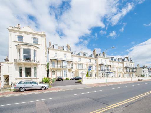
Located in Royal Tunbridge Wells in the Kent region, Mount Sion, Tunbridge Wells is a 4-star property featuring free WiFi.
Quick details for Mount Sion, Tunbridge Wells
| Hotel Name | Hotel Address | Type |
|---|---|---|
| Mount Sion, Tunbridge Wells | Mount Sion
TN1 1TZ | Hotel |
Do you own this Hotel?
Improve this listing by sending us some photos and a description of the great service you provide to guests.
How many stars would you give Mount Sion, Tunbridge Wells?

No one has voted yet. Why don't you be the first?
 | 5 Stars | |
 | 4 Stars | |
 | 3 Stars | |
 | 2 Stars | |
 | 1 Star | |
| Submit Score |
Be the first to leave a review for Mount Sion, Tunbridge Wells
Use our easy to use hotel map or comprehensive accommodation listings to find the right hotel for you.
Search by Postcode
Cheap Hotels near the Mount Sion, Tunbridge Wells hotel in
The 5 nearest Budget hotels to Mount Sion, Tunbridge Wells hotel offering economy accommodation
| Budget Hotel Name | Distance |
|---|---|
| 1:
Travelodge Tunbridge Wells | 1.04 km (0.65 Miles) |
| 2:
Premier Inn Tonbridge | 6.52 km (4.05 Miles) |
| 3:
Premier Inn Tonbridge North | 8.81 km (5.47 Miles) |
| 4:
Premier Inn Sevenoaks | 18.92 km (11.76 Miles) |
| 5:
Premier Inn Sevenoaks/Maidstone | 21.00 km (13.05 Miles) |
Hotel Deals for
Nearest Hospitals to Mount Sion, Tunbridge Wells
| Hospital Name | Operator | Distance Km | Distance Mi. |
|---|---|---|---|
| Nuffield Health, Tunbridge Wells Hospital | Kingswood Road, Tunbridge Wells, Kent, TN2 4UL | 1.91 | 1.19 |
| Kent and Sussex Hospital | THIS HOSPITAL HAS CLOSED, PLEASE VISIT THE TUNBRIDGE WELLS HOSPITAL, PEMBURY, Kent, TN2 4QJ | 5.65 | 3.51 |
| Tunbridge Wells Hospital at Pembury | Tunbridge Wells Hospital, Pembury, Tunbridge Wells, Kent, TN2 4QJ | 5.65 | 3.51 |
| Tonbridge Cottage Hospital | Tonbridge Cottage Hospital, Vauxhall Lane, Tonbridge, Kent, TN11 0NE | 5.83 | 3.62 |
Nearest Airports to Mount Sion, Tunbridge Wells
| Airport Name | Distance Km | Distance Mi. |
|---|---|---|
| Biggin Hill Airport | 34.15 | 21.22 |
| London Gatwick Airport | 47.30 | 29.39 |
| London City Airport | 48.11 | 29.89 |
| London Southend Airport | 69.45 | 43.15 |
Nearest Stations to Mount Sion, Tunbridge Wells
| Station Name | Operator | Distance Km | Distance Mi. |
|---|---|---|---|
| Tunbridge Wells
Tunbridge Wells station Mount Pleasant Road Tunbridge Wells Kent TN1 1BT | Southeastern Hastings Line | 0.38 | 0.24 |
| High Brooms
High Brooms station North Farm Road High Brooms Kent TN2 3XE | Southeastern Hastings Line | 3.05 | 1.90 |
| Frant
Frant station Bells Yew Green Frant East Sussex TN3 9BJ | Southeastern Hastings Line | 4.48 | 2.78 |
| Tonbridge
Tonbridge station Barden Road Tonbridge Kent TN9 1TT | Southeastern Redhilll to Tonbridge Line|Hastings Line|South Eastern Main Line | 7.23 | 4.49 |
| Eridge
Eridge station Groombridge Lane Eridge Green East Sussex TN3 9LE | Southern Oxted Line | 7.91 | 4.92 |
Other places to stay near Mount Sion, Tunbridge Wells
7 Mount Sion
| 7 Mount Sion |
| Distance in Km 0.00 |
 |
| View entry for 7 Mount Sion on Bed Map |
Garden Flat
| Garden Flat |
| Distance in Km 0.07 |
 |
| View entry for Garden Flat on Bed Map |
One Warwick Park Hotel
| One Warwick Park Hotel |
| Distance in Km 0.23 |
 |
| View entry for One Warwick Park Hotel on Bed Map |
Lower Pantiles Apartment
| Lower Pantiles Apartment |
| Distance in Km 0.36 |
 |
| View entry for Lower Pantiles Apartment on Bed Map |
The Tunbridge Wells Hotel
| The Tunbridge Wells Hotel |
| Distance in Km 0.47 |
 |
| View entry for The Tunbridge Wells Hotel on Bed Map |
Upper Walks, Pantiles
| Upper Walks, Pantiles |
| Distance in Km 0.48 |
 |
| View entry for Upper Walks, Pantiles on Bed Map |
Sawmill Cottage
| Sawmill Cottage |
| Distance in Km 0.56 |
 |
| View entry for Sawmill Cottage on Bed Map |
Ford Cottage
| Ford Cottage |
| Distance in Km 0.58 |
 |
| View entry for Ford Cottage on Bed Map |
Hotel Du Vin & Bistro Tunbridge Wells
| Hotel Du Vin & Bistro Tunbridge Wells |
| Distance in Km 0.67 |
 |
| View entry for Hotel Du Vin & Bistro Tunbridge Wells on Bed Map |
Mount Edgcumbe
| Mount Edgcumbe |
| Distance in Km 0.80 |
 |
| View entry for Mount Edgcumbe on Bed Map |
Russell Hotel
| Russell Hotel |
| Distance in Km 0.80 |
 |
| View entry for Russell Hotel on Bed Map |
The Royal Wells Hotel
| The Royal Wells Hotel |
| Distance in Km 0.87 |
 |
| View entry for The Royal Wells Hotel on Bed Map |
Travelodge Tunbridge Wells
| Travelodge Tunbridge Wells |
| Distance in Km 1.04 |
 |
| View entry for Travelodge Tunbridge Wells on Bed Map |
The Snap Pad
| The Snap Pad |
| Distance in Km 1.05 |
 |
| View entry for The Snap Pad on Bed Map |
The Dragon Pad
| The Dragon Pad |
| Distance in Km 1.05 |
 |
| View entry for The Dragon Pad on Bed Map |