
Search by Postcode
Map of the best Hotels near the BA16 0BF Postcode in Bullmead Close, Street
We have searched high and low to find the best hotels near the BA16 0BF postcode in the historic county of Somerset.
The BA16 0BF postcode is situated in Street. We have found hotels nearby.
Use our easy to use hotel map or comprehensive accommodation listings to find the right BA16 0BF hotel for you.
| Zoom Level | Latitude | Longitude |
| 6 | 53.521968 | -2.164306 |
Hotel Deals for BA16 0BF Postcode in Bullmead Close, Street
The Nearest Hospitals to BA16 0BF Postcode in Bullmead Close, Street
| Hospital Name | Operator | Distance Km | Distance Mi. |
|---|---|---|---|
| Glastonbury Dental Access Centre | 1 Wells Road, Glastonbury, Somerset, BA6 9DD | 3.46 | 2.15 |
| West Mendip Community Hospital | Old Wells Road, , BA6 8JD | 5.07 | 3.15 |
| Shepton Mallet NHS Treatment Centre | Shepton Mallet Treatment Centre, Old Wells Road, Shepton Mallet, Somerset, BA4 4LP | 14.61 | 9.08 |
| Shepton Mallet Community Hospital | Bucklers Way, Shepton Mallet, Somerset, BA4 4PG | 14.68 | 9.12 |
Cheap Hotels near the BA16 0BF Postcode in Street
The 10 nearest Budget hotels to the BA16 0BF Postcode offering economy accommodation
| Budget Hotel Name | Distance |
|---|---|
| 1:
Premier Inn Glastonbury | 2.03 km (1.26 Miles) |
| 2:
Travelodge Glastonbury | 2.72 km (1.69 Miles) |
| 3:
Premier Inn Wells Somerset | 13.58 km (8.44 Miles) |
| 4:
Travelodge Yeovil Podimore | 14.82 km (9.21 Miles) |
| 5:
Premier Inn Bristol Sidcot A38 | 21.94 km (13.63 Miles) |
The Nearest Airports to BA16 0BF Postcode in Bullmead Close, Street
| Airport Name | Distance Km | Distance Mi. |
|---|---|---|
| Bristol International Airport | 29.15 | 18.11 |
| Cardiff International Airport | 51.21 | 31.82 |
| Exeter International Airport | 64.23 | 39.91 |
The Nearest Stations to BA16 0BF Postcode in Bullmead Close, Street
| Station Name | Operator | Distance Km | Distance Mi. |
|---|---|---|---|
| Castle Cary | Great Western Railway | 15.80 | 9.82 |
| Bridgwater | Great Western Railway | 17.07 | 10.61 |
| Highbridge and Burnham | Great Western Railway | 18.86 | 11.72 |
Places to Stay near the BA16 0BF Postcode
Joyance
| Joyance |
| Distance in Km 0.31 |
 |
| View entry for Joyance on Bed Map |
Flat 2
| Flat 2 |
| Distance in Km 0.54 |
 |
| View entry for Flat 2 on Bed Map |
THE KING ALFRED
| THE KING ALFRED |
| Distance in Km 0.84 |
 |
| View entry for THE KING ALFRED on Bed Map |
The King Alfred
| The King Alfred |
| Distance in Km 0.85 |
 |
| View entry for The King Alfred on Bed Map |
Hygge Somerset
| Hygge Somerset |
| Distance in Km 0.99 |
 |
| View entry for Hygge Somerset on Bed Map |
Mullions 51 B&B
| Mullions 51 B&B |
| Distance in Km 1.05 |
 |
| View entry for Mullions 51 B&B on Bed Map |
Bear Inn, Somerset by Marston's Inns
| Bear Inn, Somerset by Marston's Inns |
| Distance in Km 1.08 |
 |
| View entry for Bear Inn, Somerset by Marston's Inns on Bed Map |
Wessex Hotel
| Wessex Hotel |
| Distance in Km 1.15 |
 |
| View entry for Wessex Hotel on Bed Map |
2 Bedroom Glaston Apartment
| 2 Bedroom Glaston Apartment |
| Distance in Km 1.31 |
 |
| View entry for 2 Bedroom Glaston Apartment on Bed Map |
3 Bedroom Ground Floor Glaston Apartment
| 3 Bedroom Ground Floor Glaston Apartment |
| Distance in Km 1.31 |
 |
| View entry for 3 Bedroom Ground Floor Glaston Apartment on Bed Map |
Bove Moor House Studio Flat
| Bove Moor House Studio Flat |
| Distance in Km 1.65 |
 |
| View entry for Bove Moor House Studio Flat on Bed Map |
Travelodge Glastonbury
| Travelodge Glastonbury |
| Distance in Km 2.72 |
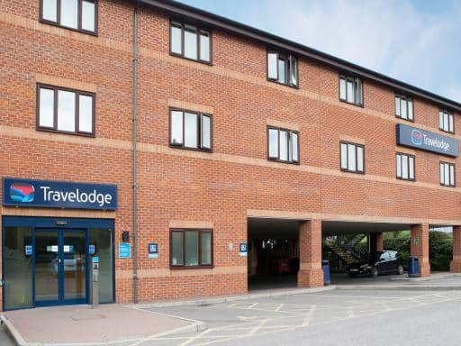 |
| View entry for Travelodge Glastonbury on Bed Map |
Cherry Plum Hideaway
| Cherry Plum Hideaway |
| Distance in Km 2.91 |
 |
| View entry for Cherry Plum Hideaway on Bed Map |
Healing Waters Sanctuary for Exclusive Use in Glastonbury
| Healing Waters Sanctuary for Exclusive Use in Glastonbury |
| Distance in Km 2.96 |
 |
| View entry for Healing Waters Sanctuary for Exclusive Use in Glastonbury on Bed Map |
Stargaia Retreat
| Stargaia Retreat |
| Distance in Km 3.32 |
 |
| View entry for Stargaia Retreat on Bed Map |
Sunnyside Lodge
| Sunnyside Lodge |
| Distance in Km 3.40 |
 |
| View entry for Sunnyside Lodge on Bed Map |
Glastonbury Escape
| Glastonbury Escape |
| Distance in Km 3.43 |
 |
| View entry for Glastonbury Escape on Bed Map |
The Glastonbury Townhouse
| The Glastonbury Townhouse |
| Distance in Km 3.53 |
 |
| View entry for The Glastonbury Townhouse on Bed Map |
Is a Hotel Missing?
Let us know the Name, Address and Postcode and we’ll add it to our listings.
Contact Us